






Folow the old logging trail from hundreds of years ago to visit the famous Moss Forest said to be the inspiration behind the imagery in the movie, Princess Mononoke.
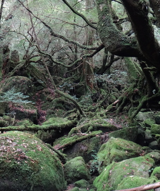 Pass by the Moss Forest made famous
by the movie, Princess Mononoke.
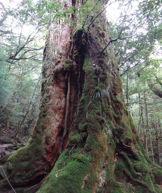 Approach the old tree called
 Nana Hon Sugi
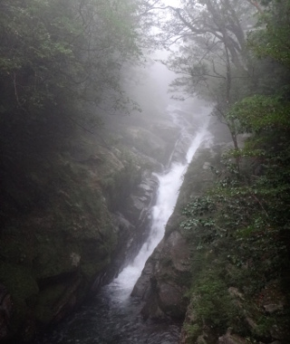 The Hiryuu (White Dragon) Cascade.
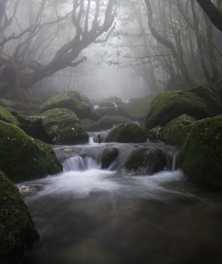 Watch out for rising water!
 Deer and sometimes monkeys are often spotted
along the roads and trail.
Deer and sometimes monkeys are often spotted
along the roads and trail.
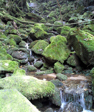 The famous Moss Forest isn't the only mossy
ravine!
The famous Moss Forest isn't the only mossy
ravine!
Links:
- Official Shiratani Unsuikyo Park Website
- Certified Guide List
- Hiking Notification
- Brochure and Island Map
- Trail Times, Bus Schedule
Content last updated in 2020.
- Experience Level:
- Beginner
-rocks/roots, water - Trail Head Access:
- Bus, Car, or Taxi
- Time:
- ~3 Hours
- Round Trip Distance:
- ** km
- Trail Head Elevation:
- 600 m
- Peak Elevation:
- ~800 m
| Deer/Monkey Sightings | ☆☆☆☆☆ |
| Yakusugi Trees | ☆☆☆☆☆ |
| Mossy Forests | ☆☆☆☆☆ |
| Vista Views | ☆☆☆☆☆ |
| Endurance | ⚠⚠⚠⚠⚠ |
| Strength & Technicality | ⚠⚠⚠⚠⚠ |
| Crowds | ⚠⚠⚠⚠⚠ |
| Weather Cancellations | ⚠⚠⚠⚠⚠ (Heavy rain, flooding, rarely road closures) |
- Costs:
-
The recommended park donation is ¥500 per hiker. Between
Shiratani Unsuikyo and Miyanoura, the bus costs around ¥600
each way.
For a guided hike, expect to pay ¥5,000~¥200,000 per hiker. - Getting to the Trailhead (GPS coords: 30.3809, 130.5751):
- The closest town is Miyanoura. YOu can take a car, taxi, or bus. There are several buses each day, and you can use the Yakutani bus pass.
- Toilets:
- There toilets at the Shiratani Unsuikyo Park parking lot and at Shiratani Hut. At this hut only, toilet paper goes in the hole in the wall.
- Equipment List:
- Water Bottle + Lunch, Rain Jacket + Rain Pants, Map + Compass, Hiking Shoes, etc.
- The Hike:
- You'll receive a map at the park entrance. If it's not immediately
obvious where the Moss Forest is, just ask, because there is a long way,
and a short way to get there.
The path near the park entrance consists of a stone sidewalk, a large bolder, and suspension bridges. From there, the route follows the Kusugawa Trail, an old trail of rocks used by Edo-period loggers. There are slippery roots, rocks, and water-crossings, but it is highly trafficked and regularly maintained trail. Signs of the force of water are everywhere. You'll enjoy crossing brooks and even through a contorted sugi tree. Just beyond the Shiratani Hut you'll encounter one of the most beloved Yaksugi trees, Nanahon Sugi. Be careful not to harm its bark or roots. Drinkable water spring out of the mountain side, and before you know it you are at the spot marked the Moss Forest (signage in Japanese, 2020).
For a half-day hike, you can simply turn around at the Moss Forest and head back the way you came. (Put your feet in the river at the park entrance if you have time.)
- Longer, More Difficult Options:
- If you have an exra 1.5 hours and want a longer, significantly more difficult hike with more moss and water, after passing the hut and going back
down through the tree, turn left on the Bugyou Sugi course. This meandering route is not only longer,
but it has a lot more ascent and descent, less traffic, and it floods easily. It should be avoided if
significant rainfall is expecteds, so check trail conditions at the park entrance before setting out.
People with at least a couple hours or more to spare often decide to continue on from the Moss Forest up the climb to Taiko Iwa, but you should watch your time.
- In the case of bad weather:
- Please do not hike on closed trails. Even if trails are currently open, they may flood if the weather changes, so
avoid crossing rivers that lead deeper into the park if water levels are rising. The Kusugawa Trail is the safest escape route. (This is the trail
that leads most directly from the front of the park, to the Moss Forest, to Tsuji Toge in the back of the park, and then
down to connect to the rail road tracks.) If the river below the hut is flooded, it is usually best to wait until the water recedes.
The only other option is to head to the Arakawa Trail Head, which is a much more difficult route and time-consuming route. Do not
attempt the Bugyou Sugi route in flooded conditions.
If the big rock at the front of the park is flooded, check the map, and you should see that you can either take the Yayoi Sugi route, or the side route that leads to the second parking lot.
Depending on your carrier, you may have service from Taiko Iwa, and also limited, intermittent cell phone service around the front of the park. There is usually wifi at the park entrance.