






Please choose from the following destinations:
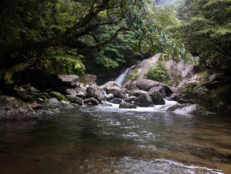
A Mystical Experience?
Shiratani-Unsuikyo Park
RECCOMMENDED FOR: Everyone!
ABOUT:
Located inland from the town of Miyanoura, the name "Shiratani-Unsuikyo" alludes to the mist and clouds that often cloak this valley
shielded from the sun by mountains in the south, east, and west. Annual rainfall of eight meters is not uncommon. As a result, this is one of the lushest, mossiest areas in
Yakushima. I give it 5-stars for photo opportunities.
TRAIL OPTIONS:
There are several routes within the park, and you can happily spend as little as one hour or as long as six hours walking
the trails. Deep within the park, there is also a trail that leads to a junction with
the rail road tracks described in the Jomon Sugi section;
if you fancy a really long, full-day hike you can even plan to visit Jomon Sugi. I choose my course according to
the weather, time, and the interests of the people I'll be hiking with. If you visit Shiratani on your own, you
will receive a map when you pay the 300 yen entrance fee during staffed hours (9:00-17:00).
TRAILS WITHIN SHIRATANI:
All trails in Shiratani have quite a bit of up-&-down. The shortest trail (and the only one accessable during heavy rains)
is a one-hour loop to Yayoi Sugi. The other two trails follow along a path of stones (uneven, but better than nothing)
used by Edo-period loggers. Then, one trail (marked as the 3-hour course in the pamphlet you'll get at the park
entrance) loops around and back for a hike through old-growth forest. The last trail (marked as the 4-hour course in the pamphlet)
goes on to the Shiratani Hut, the Moss Forest (reminiscent of Miyazaki's animated movie, Princess Mononoke),
and Tsuji Togé Junction. The trail beyond Tsuji Togé leads out of the park. Instead, from Tsuji Toge, hike up to the view point called Taiko Iwa.
This may be the most stunning view point in Yakushima.
NEED TO KNOW:
THINGS TO SEE:
Taiko Iwa View Point, Moss Forest, suspension bridge, Hiryuu Falls.
NAMED YAKUSUGI (THOUSAND-YEAR CRYPTOMERIA):
Yayoi Sugi, Nanahon Sugi, Bugyō Sugi. Other famous but younger sugi include Kuguri Sugi, Sanbon-Ashi Sugi, Ni-dai Õ Sugi,
and more.
ANIMALS: Sometimes deer and monkeys, birds depending on the season.
PLANTS: Cryptomeria, tsuga (hemlock), fir, stewartia, camellias, sakaki, Rhododendron tashiroi, Illicium anasatum, etc,
violets, as well as filmy ferns and countless mosses.
FYI: Deer have no natural predators in Yakushima. They're very approachable, but please don't feed them.
RECCOMMENDED FOR: Pople who are physically fit but have limited hiking experience, enjoy long walks, or are interested in Yakushima's logging history.
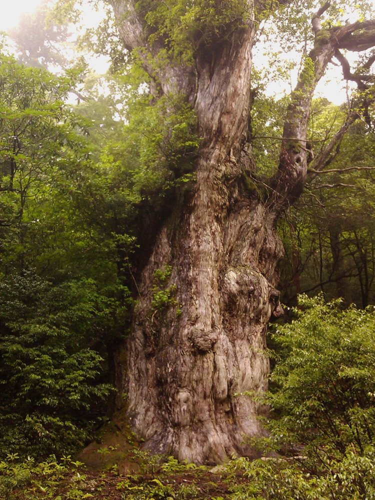
ABOUT: Of all Yakushima's known cryptomeria, Jomon Sugi has by far the largest
girth (over 16 meters) and it may also be by far the oldest. (*Update: Supposedly, they've found a bigger one, but I am not totally convinced.)Overzealous estimates based on girth yield an age of over
7,000 years (1968).
However, carbon-dating of wood near the center of the trunk only yeilds an age of around 2,170 years. That said, the trunk is hollow, and DNA tests show that all present
limbs originated from a single tree. It survived Edo-period logging when most of its neighbors were cut down, and was rediscovered
in the 1960's by a local searching for the subject of a local legend. He named it Oh-Iwa (Big Boulder) Sugi, which referred to the tree's rock-like appearance, as well
as his own name, Teiji Iwakawa. (Needless to say, that name didn't stick.)
During summer holidays, it can draw over hundreds of hikers in a day, but its fame comes at a price: Soil erosion, UV rays,
and direct damage. These days you can only view the tree from part of an observation platform. (See my blog story for details.)
TRAIL OPTIONS: Jomon Sugi can be approached from the east by trails leading from Shiratani-Unsuikyo or the Arakawa Trail Head.
It can also be approached from the west by a trail leading down from Mt. Miyanoura. The trail from Arakawa is the most popular route, and
is the one I describe here. For a two-day options, spend the night in the Takatsuka Shelter about ten minutes beyond Jomon Sugi. (There is
no water here, so bring water from the spring near Jomon Sugi.)
ARAKAWA to OKABU HODO to JOMON SUGI: If you're hiking between March 1 and November 30, traffic to the Arakawa Trail Head
is limited. Before your hike, stop at an information booth (Open daily, 8:30am-5:30pm)to check the bus schedule and buy a
round-trip bus ticket (1700 yen). It's possible to buy a bus ticket at the Yakusugi Shizenkan (Museum) bus stop
the morning of your hike as well.
The trail head has restrooms, a rest area, a box to submit hiking notification forms, and a collection bin for disposable toilet packs.
From the trail head, train tracks strech inland for 8.5 km. Follow the signs when the railroad forks. From 1923 until 1970, these tracks served the logging village of Kosugi Dani (You'll pass
the abandoned remains.) and were used to transport logs down to the town of Anbo. Now they are used mostly for maintenance operations.
At the end of the train tracks, you'll come to another large rest area with restrooms. Drinkable water is siphoned from the river. At this point,
the trail follows the Okabu Hodo for 2.5 km to Jomon Sugi. This is a steep trail with lots of roots, rocks, and stair cases.
About ten minutes into the Okabu Hodo is a small stream, which is uncrossable after extreme rains. Pause for rest at Wilson's
Stump. Quite a site in itself, this stump was named after Ernest Wilson, the plant-collector who visited Yakushima one hundred years ago.
From here on, fill your water bottle almost anywhere you see water along the trail. Ohkabu Hodo is marked with numbered yellow tags. Jomon Sugi is at
#50.
NEED TO KNOW:
THINGS TO SEE:
remains of Kosugi Dani Village, service train, Wilson's Stump
NAMED YAKUSUGI (THOUSAND-YEAR CRYPTOMERIA):
Ni-O Sugi, Okina Sugi(recently fallen), Wilson's Stump, Dai-O Sugi, Husband-&-Wife Sugi, Jomon Sugi. Also of interest is
the Third-Generation Sugi.
ANIMALS:
Deer, monkeys, and the varied tit (Parus varius).
PLANTS:
Cryptomeria, fur trees (Abies firma), Tall Stewartia, Kalopanax septemlobus,
various hydrangeas, Camellias, Symplocos myrtaceae, Rhododendron tashiroi and keiskei,
Styrax japonica, Sorbus commixta, Sakaki, Illicium anisatum,
bug-eating sundews (Drosera rotundifolia), Arisaema serratum, violets,
filmy ferns, and many others as well as countless mosses.
FYI:
The cryptomeria trees with really big girths are over 800 years old. It's pretty safe
to say that most other trees are around a few hundred years old or less (or else it they have been cut down).
RECCOMMENDED FOR: People who enjoy the hunt for the peak or who are looking for a more challenging, but well-marked and well-maintained trail.
ABOUT:
Located at the very heart of Yakushima, Mt. Miyanoura is the tallest peak (1936 meters)in Kyushu and affords a 360-degree
view of the ocean on clear days (which, in all honesty, are the minority). It's part of the traditionally
sacred Interior Mountains (Oku-Dake), which are not visible from the coastal towns.
TRAIL OPTIONS:
There are more than eight trail heads that eventually merge and lead to Mt. Miyanoura.
The options are endless: Startper in the sunny south or the wild west, pass by Jomon Sugi or the highland marsh,
return the same day or stay overnight n in one of several mountain shelters, then walk the train tracks back or
hike down to an onsen. The course I describe here begins and ends at the Yodoga Trail Head with a round-trip map time of
about 9 hours and the option to hike over Mt. Miyanoura, spend the night in the Shin-Takatsuka Hut, and hike down
past Jomon Sugi in the morning. Whatever route you choose, be ready to adapt your plans to the weather and actual trail
conditions.
YODOGAWA to HANANOEGO to MT. MIYANOURA
This route starts at the Yodogawa Trail Head (elevation = 1365 m) and reaches the peak with no dangerous stream
crossings after only 8 km, which is a shorter distance than it takes to reach some trail heads!
Along the way you'll pass the Yodogawa Hut (water and toilet stop!) and the picturesue, pale tourqouise Yodogaw
River. Then hike to the high-altitude peat marsh called Ko-Hana-no-Ego and it's big sister, Hana-no-Ego. This is
the southern-most peat marsh in Japan. From here, follow the signs for Mt. Miyanoura (宮之浦岳). You'll pass several
peaks. Refill your water at a creek before ascending Mt. Kurio. If you look around, you will find a small shrine at
the peak of both Mt. Kurio and Mt. Miyanoura. Imagine what it would have been like to pilgrimage into this sacred realm
hundreds of years ago.
NEED TO KNOW:
THINGS TO SEE:
Yodogawa River, Hana-no-Ego high-altitude peat marsh, granite formations such as "Tofu Rock", Interior Moutains (including Mt. Kuromi, Mt. Okina, and Mt. Kurio).
In the rainy season ofMay-June, the Yakushima rhododendrons in full bloom are spectacular.
NAMED YAKUSUGI (THOUSAND-YEAR CRYPTOMERIA):
(no officially named trees on this course)
ANIMALS:
Deer, the Japanese macaque, and the varied tit (Parus varius).
PLANTS:
Cryptomeria, fur trees (Abies firma), Tsuga, Kalopanax septemlobus, camellias, Symplocos myrtaceae, Yakushima Rhododendrons,
Sakaki, Illicium anisatum, bamboo grass (pseudosasa), indiginous gentians,
violets and other small alpine flowers, bug-eating sundews (Drosera rotundifolia),
and many others, as well as countless mosses.
FYI:
Yakushima was formed by a granite bubble that continues to rise around 0.3 millimeters every year.
Park Entrance
(600m elevation)----------> Yayoi Sugi Loop
(1.3km round trip)
|
Satsuki Bridge ----------> Bugyou Sugi (Old-Growth Forest) Loop
(3.5km round trip with lots of up/down and stream-crossings)
|
Shiratani Hut
(Toilet)
|
Moss Forest
(3.5km from the entrance and back)
|
Tsuji Togé Pass ----------> 25 minute loop to Taiko Iwa View Point.
(1060m elevation, 6km from the entrance and back)
Page Top
The Legendary Jomon SugiJOMON SUGI
Arakawa Trail Head
(Restrooms)
elev. 670 m<---------->
8.5 km of train tracks
Õkabu Hodō Entrance
(Restrooms)
elev. 910 m<---------->
0.6 km trailWilson's Stump <---------->
1.9km trailJomon Sugi
elev. 1280 m
Page Top
Approach to Mt. MiyanouraMt. Miyanoura
Yodogawa Trail Head ----------> Yodogawa Hut ----------> Hana no Ego ----------> Mt. Miyanoura
(Restrooms)
elev. 1365 m 1.5 km (Outhouse) 2.8 km (peat marsh)
elev. 1630 m3.5 km (then return)
elev. 1936 m
Page Top